July 15, 2015 report
Researchers develop math model to determine greatness of cities

(Phys.org)—A team of life scientists and mathematicians at Imperial College in London has created a series of formulas that together allow for determining what they deem the greatness of a city. In their paper published in Journal of the Royal Society Interface, the team describes the factors they consider to be critical in judging the greatness of a city and the formulas they developed to create a model.
According to the researchers, the one overriding factor that determines how "great" a city is, is how connected it is. Great cities, they claim help people connect, whereas those that are not so great, tend to result in isolation. With that thought in mind, they developed a series of math formulas meant to sum up features of the city that promote connectedness and then gathered data from real cities to plug into the formulas. The result is a model that not only helps determine the greatness of city, but how changes to certain factors can influence it.
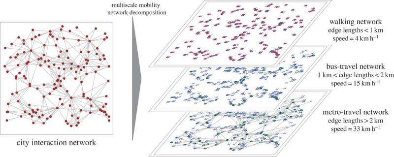
To build the formulas, the researchers came up with four principles, the first of which was a means of quantifying heterogeneity, which in turn served as a sort of measure of things like the quality or quantity of art produced, the amount of wealth and the beauty inherent in subcultures. The second revolved around the things people do, the rational choices they make etc., the third was based on resources and how they were used—as one example, how much of a person's income would they be willing to dedicate to commuting. The fourth principle sought to gauge actual opportunities for people to connect face-to-face, based on both mobility and social situations. By plugging numbers into variables in the formulas and calculating results, the team was able to come up with a general model. The generic result was also the title of their paper, "Great cities look small."
Because the model includes the introduction of factors such as census data, mobility information, topology, gross domestic product and even HIV infection rates, the team claims it can be used to accurately predict what might happen when changes are introduced to a city, such as impacts on mass transit, an increase in population or changes to the infrastructure.
More information: Great cities look small, Journal of the Royal Society Interface, DOI: 10.1098/rsif.2015.0315
Abstract
Great cities connect people; failed cities isolate people. Despite the fundamental importance of physical, face-to-face social ties in the functioning of cities, these connectivity networks are not explicitly observed in their entirety. Attempts at estimating them often rely on unrealistic over-simplifications such as the assumption of spatial homogeneity. Here we propose a mathematical model of human interactions in terms of a local strategy of maximizing the number of beneficial connections attainable under the constraint of limited individual travelling-time budgets. By incorporating census and openly available online multi-modal transport data, we are able to characterize the connectivity of geometrically and topologically complex cities. Beyond providing a candidate measure of greatness, this model allows one to quantify and assess the impact of transport developments, population growth, and other infrastructure and demographic changes on a city. Supported by validations of gross domestic product and human immunodeficiency virus infection rates across US metropolitan areas, we illustrate the effect of changes in local and city-wide connectivities by considering the economic impact of two contemporary inter- and intra-city transport developments in the UK: High Speed 2 and London Crossrail. This derivation of the model suggests that the scaling of different urban indicators with population size has an explicitly mechanistic origin.
Journal information: Journal of the Royal Society Interface
© 2015 Phys.org


