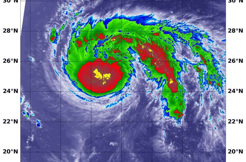
NASA finds classic comma-shape in tropical storm Faxai

NASA's Aqua satellite passed over the Northwestern Pacific Ocean and looked at comma-shaped Tropical Storm Faxai in infrared light.
At 11 a.m. EDT (1500 UTC), the Joint Typhoon Warning Center or JTWC reported that Tropical Storm Faxai had maximum sustained winds near 55 knots (63 mph/102 kph). JTWC said the storm is intensifying and that is evident by the powerful thunderstorms that NASA's Aqua satellite found using infrared imagery.
Faxai was located near 24.7 degrees north latitude and 148.1 degrees east longitude, about 371 nautical miles east of Iwo To Island, Japan. Faxai was moving to the west-northwest.
On Sept. 6 at 11:40 a.m. EDT (1540 UTC), the Moderate Imaging Spectroradiometer or MODIS instrument that flies aboard NASA's Aqua satellite used infrared light to analyze the strength of storms within the storm.
NASA researches tropical cyclones with satellites, field missions and computer modeling to determine how they rapidly intensify, develop and behave.
Tropical cyclones are made of up hundreds of thunderstorms, and infrared data can show where the strongest storms are located. They can do that because infrared data provides temperature information, and the strongest thunderstorms that reach highest into the atmosphere have the coldest cloud top temperatures.
MODIS found those strongest storms were around the center of circulation where cloud top temperatures were as cold as minus 80 degrees Fahrenheit (minus 62.2 Celsius). NASA research has found that cloud top temperatures that cold indicate strong storms with the potential to generate heavy rainfall. Those strong storms were surrounded by slightly less powerful storms that also extended in a band of thunderstorms that formed a "tail" stretching from the north to the east. That large, thick band of strong thunderstorms helped give Faxai the comma shape.
Faxai is forecast to move to the west-northwest and turn north after three days where it is forecast to make landfall near Tokyo at 80 knots (92 mph) on Sept. 8.
Provided by NASA's Goddard Space Flight Center


