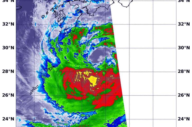
NASA follows tropical storm Krosa's approach to landfall in southern Japan

Infrared imagery from NASA's Aqua satellite shows that Tropical Storm Krosa contains powerful thunderstorms with heavy rain capabilities as it moves toward landfall in southern Japan. Krosa's center is expected to make landfall in the western part of Shikoku Island, Japan.
On Aug. 14, 2019, the Japan Meteorological Agency has issued warnings for Kyushu, Shikoku and southeastern portions of Honshu. Because Krosa is such a large storm, it is expected to affect all of the big islands of Japan.
At 12:05 a.m. EDT (0505 UTC), the Moderate Imaging Spectroradiometer or MODIS instrument that flies aboard NASA's Aqua satellite used infrared light to examine the storm. Infrared data provides temperature information, and the strongest thunderstorms that reach high into the atmosphere have the coldest cloud top temperatures.
Aqua's MODIS found strongest thunderstorms in a small area southwest of the center where cloud top temperatures were as cold as minus 80 degrees Fahrenheit (minus 62.2 Celsius). That area was surrounded by a much larger area with powerful storms as cold as minus 70 degrees Fahrenheit (minus 56.6 Celsius). Cloud top temperatures that cold indicate strong storms with the potential to generate heavy rainfall.
The Joint Typhoon Warning Center or JTWC noted at 11 a.m. EDT (1500 UTC) that Krosa had maximum sustained winds near 45 knots (52 mph/83 kph). Krosa was centered near 31.0 degrees north latitude and 132.7 degrees east longitude. Tropical storm Krosa was located approximately 237 nautical miles south of Iwakuni, Japan. Krosa has tracked north-northwestward.
After the storm makes landfall in Kyushu, Japan, it is forecast to pass to the south of the Korean peninsula, and turn to the northeast as it becomes extra-tropical over the Sea of Japan.
Provided by NASA's Goddard Space Flight Center


