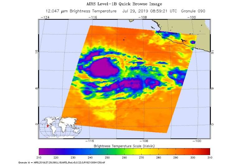
NASA takes tropical storm Flossie's temperature

NASA's Aqua satellite took the temperature of Tropical Storm Flossie as it continued to strengthen and organize in the Eastern Pacific.
Tropical Depression 7E formed in the Eastern Pacific Ocean on Sunday, July 28 about 580 miles (930 km) south-southwest of Manzanillo, Mexico. On July 29 at 5 a.m. EDT (0900 UTC), the depression strengthened into a tropical storm and was renamed Flossie.
Infrared light enables NASA to take the temperatures of clouds and thunderstorms that make up tropical cyclones. The stronger the storms are indicate that they extend high into the troposphere and have cold cloud top temperatures.
An infrared look at Flossie by NASA's Aqua satellite on June 29, at 0459 UTC (0859 UTC) revealed where the strongest storms were located within the system. The Atmospheric Infrared Sounder or AIRS instrument aboard NASA's Aqua satellite analyzed Flossie and found cloud top temperatures of strongest thunderstorms as cold as or colder than minus 63 degrees Fahrenheit (minus 53 degrees Celsius) circling the center. Cloud top temperatures that cold indicate strong storms that have the capability to create heavy rain.
NOAA's National Hurricane Center or NHC noted, "A series of fortuitous microwave images was helpful in locating the center of circulation and revealed significant banding improvements in the south semicircle portion of the cyclone."
At 11 a.m. EDT (5 a.m. HST/1500 UTC), the center of Tropical Storm Flossie was located near latitude 12.5 degrees north and 114.6 degrees west longitude. Flossie is far from land areas, so there are no coastal watches in effect. Flossie's center is about 780 miles (1,260 km) south-southwest of the southern tip of Baja California, Mexico.
NHC said Flossie is moving toward the west near 18 mph (30 kph) and this general motion is forecast to continue through Tuesday night, July 30. Maximum sustained winds have increased to near 50 mph (85 kph) with higher gusts.
Further strengthening is expected, and Flossie is expected to become a hurricane on Tuesday.
Provided by NASA's Goddard Space Flight Center


