GPM satellite provides a 3D look at Tropical Storm Barry

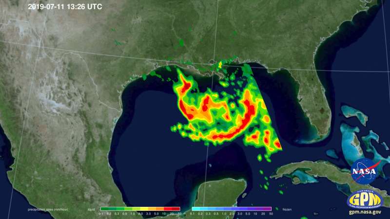
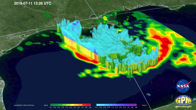
The Global Precipitation Measurement mission or GPM core satellite provided a couple of views of Tropical Storm Barry that showed its cloud heights and rainfall rates.
Tropical Storm Barry formed during the morning of July 11 and the National Hurricane Center has issued several warnings and watches. A Tropical Storm Warning is in effect from the mouth of the Pearl River to Morgan City. A Storm Surge Warning is in effect from the mouth of the Atchafalaya River to Shell Beach. A Storm Surge Watch is in effect for Shell Beach to the Mississippi/Alabama border and for the mouth of the Atchafalaya River to Intracoastal City.
There is also a hurricane and tropical storm watch in effect. A Hurricane Watch is in effect from the mouth of the Mississippi River to Cameron and a Tropical Storm Watch is in effect from east of the Mouth of the Pearl River to the Mississippi/Alabama border and for Lake Pontchartrain and Lake Maurepas including metropolitan New Orleans.
NASA and the Japan Aerospace Exploration Agency's (JAXA) GPM Core Observatory passed over developing Tropical Depression 2 (which was upgraded to Tropical Storm Barry later in the morning) in the Gulf of Mexico the morning of July 11, 2019 at 8:26 a.m. CDT, capturing estimates of rainfall rates within the storm using GPM's Microwave Imager (GMI) instrument.
GPM's Dual-frequency Precipitation Radar (DPR) measured storm top heights as high as 18 kilometers (11.1 miles), which is extremely high and indicative of intense thunderstorm activity south of central Louisiana. Rainfall rates with these storms exceeded 100 mm/hour (4 inches/hr) as well. Despite these intense storms, activity was not yet organized near the storm center and so flooding due to rainfall, rather than strong winds and storm surge, are the primary threat with Barry at this time.

At 2 p.m. EDT (1800 UTC), the center of Tropical Storm Barry was located near latitude 27.8 North, longitude 89.0 West. Barry is moving toward the west near 5 mph (7 km/h) and this motion is expected to continue today. Reports from an Air Force Reserve Hurricane Hunter aircraft indicate that maximum sustained winds are near 40 mph (65 kph) with higher gusts.
Tropical-storm-force winds extend outward up to 90 miles (150 km) mainly to the southeast of the center. The minimum central pressure based on aircraft and surface observations is 1006 millibars (29.71 inches).
The National Hurricane Center noted that "Strengthening is expected during the next day or two, and Barry could become a hurricane late Friday or early Saturday [July 13].
A turn toward the west-northwest is expected tonight, followed by a turn toward the northwest on Friday. On the forecast track the center of Barry will be near the central or southeastern coast of Louisiana Friday night or Saturday."
More information: For updated forecasts, visit: http://www.nhc.noaa.gov
Provided by NASA's Goddard Space Flight Center


