GPM satellite finds heavy rainfall in powerful Hurricane Lane

Hurricane Lane had moved westward into the central Pacific Ocean far southeast of the Hawaiian Islands when NASA's GPM core observatory satellite passed above and looked it the heavy rainfall it was generating. Hurricane Lane may be a threat to portions of the Hawaiian Islands this week.
Hurricane Lane intensified and had maximum sustained winds reaching about 105 knots (~ 121 mph) when GPM passed overhead on August 19, 2018 at 12:43 p.m. EDT (1643 UTC). This made it a category three on the Saffir-Simpson hurricane wind scale.
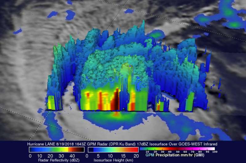
The GPM satellite's Microwave Imager (GMI) and Dual-Frequency Precipitation Radar (DPR) instruments provided highly accurate information about precipitation within the hurricane. GPM's GMI revealed rainfall coverage and GPM's radar (DPR Ku Band) provided precise rainfall intensity measurements near the hurricane's eye. GPM's radar found that rain was falling at a rate of over 89 mm (3.5 inches) per hour in an intense feeder band wrapping around the northern side of the hurricane. GPM's DPR (shown in lighter shades) also measured precipitation in powerful storms in Lane's eye wall that were dropping rain at a rate of over 143 mm (5.6 inches) per hour.
The GPM satellite's radar data (DPR Ku Band) were used to provide a unique 3-D cross-section view of rainfall intensity in hurricane LANE's eye wall. DPR revealed that very strong downpours there were returning radar reflectivity values greater than 57 dBZ to the GPM satellite. GPM's Ku band radar is capable of showing the 3-D structure of precipitation to heights of 19 km (11.8 miles). Those GPM radar data revealed that the tops of very powerful storms in Lane's eye wall were reaching heights above 14.3 km (8.9 miles). GPM is a joint mission between NASA and the Japan Aerospace Exploration Agency, JAXA.
On Aug. 20, NOAA's Central Pacific Hurricane Center or CPHC in Honolulu, Hawaii cautioned "All interests in the Hawaiian Islands, including the Northwestern Hawaiian Islands, should continue to closely monitor the progress of Lane this week. On the current forecast track, a Tropical Storm or Hurricane Watch may be required for parts of Hawaii later today or tonight."
At 5 a.m. HST/11 a.m. EDT/1500 UTC, the center of Hurricane Lane was located near latitude 13.7 degrees north and longitude 148.2 degrees west. Lane is moving toward the west near 14 mph (22 kph), and this general motion is expected to continue today. Lane is forecast to move westward at a slightly slower forward speed from tonight through early Tuesday, followed by a turn toward the west-northwest starting late Tuesday.
Maximum sustained winds are near 125 mph (205 kph) with higher gusts. Lane is a category 3 hurricane on the Saffir-Simpson Hurricane Wind Scale. Little change in strength is expected through early Tuesday, with some weakening possible starting late Tuesday.
CPHC cautioned "Large swells generated by Lane will impact the Hawaiian Islands this week. These swells will likely produce large and dangerous surf, as well as strong currents, along some shorelines."
For updated forecasts, visit: http://www.prh.noaa.gov/cphc
Provided by NASA's Goddard Space Flight Center


