NASA measures Tropical Cyclone Nora's flooding rains in Queensland

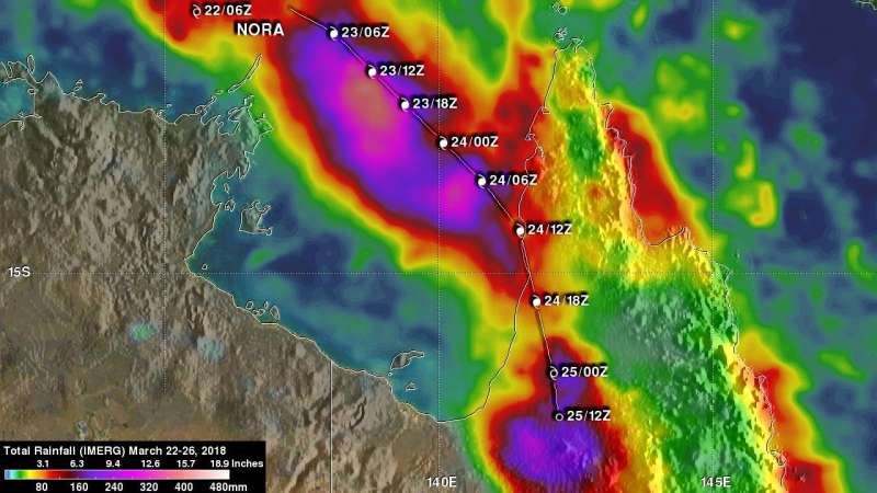
NASA used satellite data to calculate the heavy rainfall created by Tropical Cyclone Nora as it came ashore in northwestern Queensland on March 24, 2018.
Nora reached peak intensity of 95 knots (109 mph) was reached when it was moving through the central northern Gulf of Carpentaria. Winds had decreased slightly to 90 knots (104 mph) by landfall. The Australian Bureau of Meteorology (BOM) reported that Nora produced over 110 mm (4.3 inches) of rain in 24 hours.
Flooding, landslides, lost electrical power, and structural damage were also a companion of the tropical cyclone's arrival. After landfall Nora weakened but the remnants continued to produce heavy precipitation. Nora was no longer a significant tropical cyclone after March 25 at (8 a.m. EDT (1200 UTC). Australia's BOM rainfall analyses indicate that over 200 mm (7.9 inches) of rain accompanied tropical cyclone Nora in parts of northwestern Queensland.
At NASA's Goddard Space Flight Center in Greenbelt, Maryland a rainfall accumulation analysis was conducted. The analysis was derived from NASA's Integrated Multi-satellitE Retrievals data (IMERG). IMERG data were used to calculate estimates of precipitation totals from a combination of space-borne passive microwave sensors, including the GMI microwave sensor on the GPM satellite, and geostationary IR (infrared) data.
NASA's Precipitation Measurement Missions (PMM) science team at NASA Goddard has developed algorithms that support GPM (Global Precipitation Measurement) missions such as IMERG. GPM is a joint mission between NASA and the Japan Aerospace Exploration Agency, JAXA.
The rainfall analysis showed an estimate of IMERG rainfall accumulation totals during the period from March 22 to 26, 2018.
During that time, Tropical cyclone Nora formed, traveled over the Gulf of Carpentaria and dissipated over northwestern Queensland.
The IMERG analysis indicated that the heaviest precipitation with Nora occurred over the Gulf of Carpentaria where over 433 mm (17 inches) of rain fell. More than 260 mm (10.2 inches) of rain was indicated by IMERG along Nora's track into northwestern Queensland.
On March 27, the BOM noted that there were still some flood warnings for rivers in Queensland. For the full list or watches and warnings, visit: http://www.bom.gov.au/qld/warnings/.
Provided by NASA's Goddard Space Flight Center


