Daily dam releases on Massachusetts' Deerfield river reduce downstream flows

In the first-of-its-kind study of the environmental effects of hydropeaking, that is releasing water at hydropower dams to meet peak daily electricity demand, two University of Massachusetts Amherst researchers say their unexpected findings suggest that about 10 percent of released water may be permanently lost, making that water unavailable to downstream users and wildlife.
In the first study to document water losses due to hydropeaking, hydrogeologists Brian Yellen, who received his master's degree for the work, with his advisor assistant professor of geosciences David Boutt, report details in a recent issue of the journal Hydrological Processes.
Yellen says, "The most interesting thing we found is something we weren't looking for. That is, in this 13-mile stretch of the river, about 10 percent of water released from the dam every day gets pushed into the aquifer and is lost permanently."
The surprise finding is not going to end power companies' practice of hydropeaking, which allows the grid to operate more efficiently, Yellen acknowledges, "but we found a tradeoff that wasn't understood before. It's one additional tradeoff of which we're now aware. This is big news for downstream fish and fishermen, ecosystems, swimmers, boaters, municipal water supplies, industry and anyone else who uses water downstream from a dam. There may be water lost upstream that they are never going to see."
As he explains, "When you walk down a river in rainy places, as in New England, you expect the river to get bigger, not smaller. What we observe here is that the Deerfield River's flow actually decreases as you go downstream. Even though several small streams enter the river, hydropeaking drives enough water out of the river to overwhelm the additions from tributaries."
He and Boutt conducted their study on a stretch of the Deerfield River in remote western Massachusetts, from just below the Fife Brook Dam down to a U.S. Geological Survey river gauge in the village of Charlemont. The river depth changes daily in the area, rising about two feet when water is released from the dam and falling about two feet when the water release ends, Yellen notes.
"When it's low you can wade across, when it comes up you'll be up to your neck," he explains. "It's a natural lab where we can observe how these changes affect the groundwater or the aquifer that is right under the river, where river water and groundwater come into contact with one another. On the Deerfield, there is a flood every day."

The researchers came to their conclusions by estimating the flow of water into and out of a section of the Deerfield River using a variety of methods. Each showed that water was leaving the river due to dam operations. Further, a neighboring reference river that does not have hydropeaking showed the expected downstream increase in river flow.
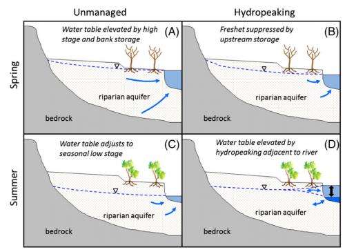
Scientists once thought that when a dam release increases a river's depth, the "temporary flood" would have little effect on the groundwater in surrounding terrain. But at least in the heavily forested terrain near the Deerfield River, Yellen says, "Our data suggest that lost water is getting sucked up by trees in the valley that normally wouldn't have access to groundwater. But the groundwater table is being raised so high that the roots can reach it, and they take it."
Yellen clarifies that the water table doesn't rise up so high during the high-water floods so that tree roots are actually standing in it, but the soil toward the surface wicks water farther up so they can take some. "We knew this system would pump river water into the groundwater when the water is high," he adds. "We expected that process would occur, but we were surprised by the loss of 10 percent of the flood water daily."
He adds, "We present convincing evidence that hydropeaking raises the water table and makes it easier for trees on the bank to use that water. Every drop that the trees use is one less for the river and organisms that live there." On an undammed river, such a flood would happen naturally two or three times a year, but on the Deerfield River, "every single day there is a flood in the middle of the day and this is particularly true in summer."
Yellen and Boutt say further work is needed to determine how generalizable their result is, and whether the phenomenon is occurring on other rivers. "Dammed rivers all across the United States have hydropeaking and we expect that associated losses are occurring in other regions," Yellen says. "This was our test case. How widespread it is remains to be seen."
Provided by University of Massachusetts Amherst


