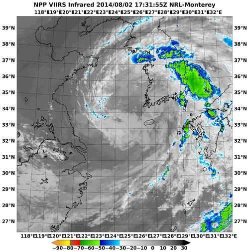
NASA catches the brief life of Tropical Storm Nakri

The low pressure area known as System 96W struggled to organize for a week and finally became Tropical Storm Nakri on August 2 as the Suomi NPP satellite passed overhead. Nakri had a short life, however, as it dissipated the following day while approaching South Korea.
On Saturday, August 2, at 9 p.m. EDT, Nakri's maximum sustained winds were near 40 knots (46 mph/74 kph). At that time it was centered about 100 nautical miles southeast of Kunsan Air Base, near 35.0 north and 125.0 east. It was moving to the north at 14 knots (16.1 mph/21.9 kph).
When NASA-NOAA's Suomi NPP satellite passed over Nakri on August 2, the Visible Infrared Imaging Radiometer Suite (VIIRS) instrument aboard captured an infrared image of the storm. The VIIRS instrument showed a tightly wrapped center with fragmented bands of thunderstorms wrapping into the center. VIIRS also showed the heaviest precipitation was falling east of the center of circulation.
VIIRS collects visible and infrared imagery and global observations of land, atmosphere, cryosphere and oceans. VIIRS flies aboard the Suomi NPP satellite, which is managed by both NASA and NOAA.
By 1900 UTC (5 p.m. EDT) on August 3, the Joint Typhoon Warning Center issued its final advisory on Nakri. By that time, Nakri had already weakened to a tropical depression. It was centered near 36.1 north and 125.8 east, about 15 nautical miles (17.2 miles/27.8 km) northwest of Kunsan Air Base. Later on August 3, Nakri dissipated on approach to the Korean peninsula.
Provided by NASA's Goddard Space Flight Center


