July 23, 2012 report
Investigative team finds river spillway flooding caused new land formation in Louisiana

(Phys.org) -- A team of geologists, civil engineers and one representative from the US Army Corp of engineers has found that when a spillway was opened last year to prevent flooding of the Mississippi river from drowning New Orleans, new land was created. The team, which has had their paper on the topic printed in the journal Nature Geoscience, says that this is the first time new land formation has been documented this way and now the technique might be used in the future to build up eroded lands.
In the spring of 2011, the Mississippi river became engorged as record amounts of snow melted along its northern route. The result was record flooding over a period of a month as news media marked its ominous march south. But because it took awhile for the extra water to reach areas in the south, planners had time to take action to best protect the most populated areas. They opened levees allowing water to spill over farmlands, enraging farmers, but saving many villages, towns, and even cities such as New Orleans, which of course was flooded in the aftermath of hurricane Katrina just seven years ago.

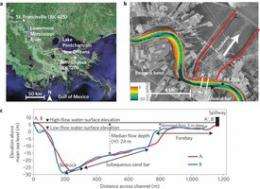
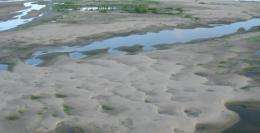
To save New Orleans, engineers opened levees (using dynamite) allowing water to enter the Bonnet Carré Spillway, which was dug for just that purpose after a massive flood back in 1927. The tactic worked, sparing New Orleans from what might have been a fatal blow. But another unexpected positive outcome appears to have been the formation of new land in some of the areas that had been flooded. It was a surprise because just ten to fifteen percent of the water volume from the river was diverted, which was mostly surface water, yet some thirty to forty percent of the silt load it was carrying managed to make its way into the spillway. The result was new land development adjoining the river and massive silt deposits left behind on the farmlands that had been covered. The research team says that until now, such land development has only been theorized, never documented.
Now, because it’s been seen in action, engineers and conservation groups can study areas that might benefit from temporary flooding, and perhaps dig spillways to make it happen. One idea is to use such spillways to restore delta lands that have eroded due to farming over many years. Another is to build up lands around areas that tend to flood regularly to build up natural barriers.
More information: Mitigating land loss in coastal Louisiana by controlled diversion of Mississippi River sand, Nature Geoscience (2012). doi:10.1038/ngeo1525
Abstract
After the 1927 flood of record on the Mississippi River, the Bonnet Carré Spillway in Louisiana was constructed as a flood control operation. When it is opened, the spillway diverts floodwaters from the Mississippi River to Lake Pontchartrain1, to reduce the water discharge flowing past New Orleans. During the 2011 Mississippi River flood, which had the highest peak discharge since 1927, the Bonnet Carré Spillway was opened for 42 days, from 9 May to 20 June. During this period, the average spillway discharge of 6,010 m3 s−1 amounted to 10–20% of the total river flood discharge. Here we present measurements of the areal extent and thickness of new sediments in the floodway, following the 2011 Mississippi flood. Only the upper 10–15% of the river water column was skimmed into the floodway. Yet, we conservatively estimate that 31–46% of the total sand load carried by the Mississippi River during the period of spillway opening was diverted. We find that local river conditions led to increased concentrations of suspended sand in the upper water column and thus led to diversion of sand from the river into the spillway. We conclude that an appropriate design of engineered river diversions in Louisiana can help mitigate coastal wetland loss.
Journal information: Nature Geoscience
© 2012 Phys.org


