Carbon storage in tropical vegetation: New map to help developing nations track deforestation, report on emissions

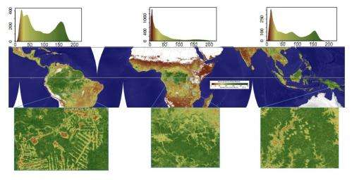
A study published in Nature Climate Change today finds that tropical vegetation contains 21 percent more carbon than previous studies had suggested. Using a combination of remote sensing and field data, scientists from Woods Hole Research Center (WHRC), Boston University, and the University of Maryland were able to produce the first "wall-to-wall" map (with a spatial resolution of 500 m x 500 m) of carbon storage of forests, shrublands, and savannas in the tropics of Africa, Asia, and South America. Colors on the map represent the amount of carbon density stored in the vegetation in a continuum fashion (Figure 1). Reliable estimates of carbon storage are critical to understanding the amount of carbon released into the atmosphere by changes in land cover and land use.
Tropical deforestation is considered a major source of the greenhouse gases that cause climate change, releasing as much as 1.1 billion tons of carbon into the atmosphere each year. Based on new data in this study, researchers believe that current models may overestimate the net flux of carbon into the atmosphere due to tropical vegetation loss by 11 to 12 percent. For countries trying to meet their greenhouse gases reporting requirements under the United Nations Framework Convention on Climate Change (UNFCCC), these new data are particularly important.
Lead author Alessandro Baccini, an assistant scientist at WHRC, explained that the new data set provides a spatially and temporally consistent estimate of carbon stock and a stronger foundation for estimating carbon emissions by better characterizing the carbon density of the forest that has been lost. "For the first time we were able to derive accurate estimates of carbon densities using satellite LiDAR observations in places that have never been measured," said Baccini. "This is like having a consistent, very dense pantropical forest inventory."
In many developing nations, deforestation is the largest source of emissions of greenhouse gases. In order to reliably report emissions to the UNFCCC, and to participate in international schemes such as Reducing Emissions from Deforestation and Forest Degradation (REDD+), which provides compensation for avoiding deforestation, these countries need an accurate way to calculate stored carbon and to track deforestation and reforestation. "We worked closely with collaborators in 12 countries around the tropics to collect the field data needed to calibrate the satellite measurements and ensure relevance for their national reporting," said co-author Nadine Laporte, a WHRC associate scientist, who coordinated field measurements in Africa.
"The paper is important for two reasons," said co-author and WHRC senior scientist Richard A. Houghton. "First, it provides a high-resolution map of aboveground biomass density for the world's tropical forests. Previous maps were of much coarser resolution and yielded wildly different estimates of both regional totals and spatial distribution. Second, the paper calculates a new estimate of carbon emissions from land-use change in the tropics."
This was done using the co-location of biomass density and deforestation to assign a more representative carbon density to the forests cleared. Previous estimates used 'average' biomass densities that may have biased emissions' estimates. In short, the approach will lead to better tracking of changes in biomass density resulting from degradation and growth.
This will in turn help nations, projects, and groups of all kinds determine better estimates of carbon emissions. These estimates are required nationally for UNFCCC reporting and would support REDD+ should it be implemented. "The study represents a major step forward in the effort to map the current state of global tropical biomass stocks," commented Greg Asner, an ecologist at the Carnegie Institution for Science. "The 500m resolution of the map will help countries implement activities to improve forest management and to help fight climate change through reduced carbon emissions from deforestation."
The scientists estimated that tropical forests in America store around 118 billion tons of carbon, a fifth more than indicated by previous findings. For the first time in a large-area mapping effort of this kind, an end-to-end approach was constructed quite literally from the ground up, beginning with a pantropical field campaign, relying on the work of scholars in many different countries, and designed for the optimal integration of field and satellite data. The result is a carbon density map for the tropics with a level of consistency and accuracy never before achieved
Global measurements of where carbon is accumulating and where it's being lost will be used to better quantify how many carbon credits would be needed to reduce carbon emission under the UNFCCC and, when carbon is valued, to quantify financial rewards. As Richard A. Houghton said, "Your forest may be worth more if it's accumulating more carbon than another forest."
"Coupling the Lidar and field measurements is what makes this study and our map so unique, and powerful" notes study co-author and WHRC senior scientist Scott Goetz. "Without measurements from a satellite-based Lidar, a study of this nature would not have been possible. We need that capability going forward."
More information: Zoomable map is available here: www.whrc.org/mapping/pantropic … /carbon_dataset.html
Journal information: Nature Climate Change
Provided by Woods Hole Research Center


