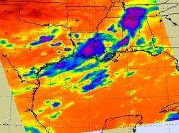
NASA's Aqua Satellite sees TD5's remnants stretched out in US south

NASA's Aqua satellite noticed that the showers and thunderstorms from the remnants of Tropical Depression 5 (TD5) extended from Louisiana northeast into southwest Alabama. Infrared imagery indicated some strong thunderstorms over south central Louisiana and northwest Alabama.
NASA's Atmospheric Infrared Sounder (AIRS) instrument that flies aboard the Aqua satellite captured an infrared image of TD5's remnants on August 18 at 19:23 UTC (3:23 p.m. EDT). In the image showers and clouds stretched from Louisiana northeast into Tennessee. The clouds over Louisiana and southern Alabama were part of TD5. The clouds and showers in north central Alabama and Tennessee were generated by a shortwave trough (elongated area of low pressure) moving through Tennessee.
During the time of the AIRS image, the strongest thunderstorms and convection (rapidly rising air that forms thunderstorms) were located over south central Louisiana and north central Alabama. Both of those areas experienced heavy rainfall at that time yesterday.
NASA false-colors infrared satellite imagery to show cold and warm areas. The higher, coldest cloud tops of stronger storms are depicted in purple in AIRS infrared images. Those high thunderstorms are as cold as or colder than 220 Kelvin or minus 63 degrees Fahrenheit (F). Warm temperatures, such as those from warm land or sea surfaces are depicted in shades of orange and red (the hottest).
On August 19 at 1:00 p.m. EDT, the lingering remnants of Tropical Depression 5, were over southern Mississippi. TD5's remnants are forecast to drift slowly eastward today and bring numerous showers and thunderstorms to southwestern Alabama. The heavy rainfall has been producing flash flooding over Mississippi. Flooding is now possible today over southwestern Alabama because of the remnants slow motion. To see the current National Weather Service (NWS) radar from Montgomery, Ala., visit this page.
The NWS forecast for Meridian, Mississippi, a city located on the east central portion of the state, close to the Alabama border, includes heavy rainfall from showers and thunderstorms. Some of those thunderstorms were dropping between 1 and 2 inches of rainfall. The forecast also notes clouds to ground lightning and gusty winds up to 30 mph. The showers and thunderstorms are forecast to diminish by nightfall.
Located northeast of Meridian, Miss., the town of Livingston, Alabama is also forecast to experience heavy rainfall near and east of a line from the towns of Oneonta to Demopolis as TD5's remnants continue their slow crawl.
TD5's remnants will continue to crawl eastward on Friday as the NWS forecast office in Georgia expects that TD5's remnants to push into the area near Columbus on August 20, triggering showers and thunderstorms.
Provided by NASA's Goddard Space Flight Center


