January 8, 2014 report
Researchers combine "terra preta" finds with statistics to map early Amazonian population centers

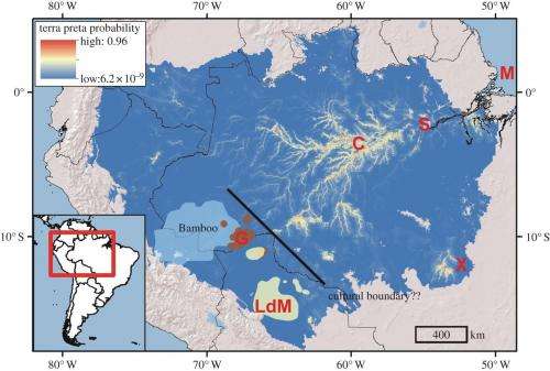
(Phys.org) —A team of researchers from the U.S. and Brazil has created a virtual map of possible ancient human population centers in the Amazonian jungle by using statistical methods that connect modern terra preta areas. In their paper published in Proceedings of the Royal Society B: Biological Sciences, the team describes how they applied archeological site information with statistics to come up with a way to guess where other early population sites might be.
Despite years of work, modern scientists still don't really know much about the people that populated that Amazonian basin prior to the arrival of European explorers. The dense jungle growth has made it difficult to study the area, and the preponderance of poor soils suggests that the area could not have supported large groups of people anyway—the soil would not support the farming necessary to support them. In more recent times, some evidence (ancient roads and earthworks) has been uncovered that indicates that large settlements of people may indeed have indeed populated the area, which would have been made possible by a soil enrichment technique known as terra preta (adding nutrients that resulted in fertile "black earth" that can still be seen today.). Because very few terra preta sites have been found, researchers aren't sure if they are few and far between, or if there are more simply hidden in the jungle.
To find out, the researchers with this new effort created maps that displayed all of the known terra preta locations. They then noted geographical details about each site and discovered there were some possible correlations between them, e.g most tended to exist on bluffs overlooking rivers. Using such information, they applied statistical analysis to maps of the area and came up with a model that predicted where other terra preta locations may be found. Their results indicate that more than three percent of the total Amazonia basin may be hiding terra preta sites.
The team has not been able to test their maps yet, so it's not yet known how accurate their guesses may be, but the hope is that by uncovering more terra preta sites, more information can be gleaned from the area to help uncover chapters of human history in South America that until now have remained hidden.
More information: Predicting pre-Columbian anthropogenic soils in Amazonia, Published 8 January 2014 DOI: 10.1098/rspb.2013.2475
Abstract
The extent and intensity of pre-Columbian impacts on lowland Amazonia have remained uncertain and controversial. Various indicators can be used to gauge the impact of pre-Columbian societies, but the formation of nutrient-enriched terra preta soils has been widely accepted as an indication of long-term settlement and site fidelity. Using known and newly discovered terra preta sites and maximum entropy algorithms (Maxent), we determined the influence of regional environmental conditions on the likelihood that terra pretas would have been formed at any given location in lowland Amazonia. Terra pretas were most frequently found in central and eastern Amazonia along the lower courses of the major Amazonian rivers. Terrain, hydrologic and soil characteristics were more important predictors of terra preta distributions than climatic conditions. Our modelling efforts indicated that terra pretas are likely to be found throughout ca 154 063 km2 or 3.2% of the forest. We also predict that terra preta formation was limited in most of western Amazonia. Model results suggested that the distribution of terra preta was highly predictable based on environmental parameters. We provided targets for future archaeological surveys under the vast forest canopy and also highlighted how few of the long-term forest inventory sites in Amazonia are able to capture the effects of historical disturbance.
Journal information: Proceedings of the Royal Society B
© 2014 Phys.org


